Connect With Us
Have questions about your visit, need assistance planning your trip, or want to learn more about Sauder Village? Our team is happy to assist you!
Toll-Free: 1.800.590.9755 or 419.446.2541 | E-Mail: [email protected] | Mail: Sauder Village. PO Box 235, Archbold, OH 43502

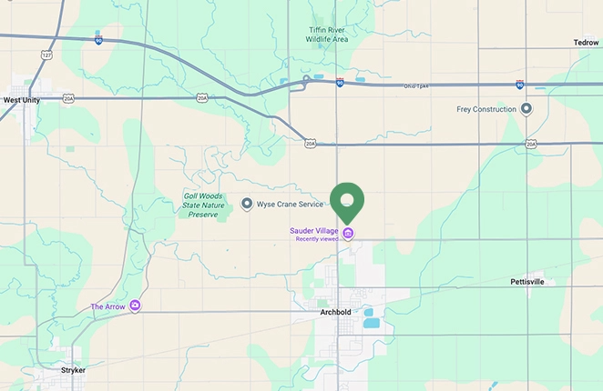
Directions to Sauder Village
Download a printable PDF of directions to Sauder Village:


Address:
22611 State Route 2
PO Box 235
Archbold, OH 43502
Admission Rates and Hours
Plan your visit with confidence! View our seasonal hours, special dates, and more.
Historic Village
The Historic Village re-opens April 29, 2026.
Open yet in 2025 on Dec. 5, Dec. 6 and Dec. 13 for our holiday programming.
Historic Village admission
Adults: $28
Students (ages 4-17): $22
Children (ages 3 and under): Free
Seniors (60 and over): $26
We offer AAA, Military, Veteran and Museum for All Discounts.
Exhibit Only admission to Quilt Show, Rug Hooking Week and Woodcarvers Show: $15.00 per adult/$11.00 per student (4-17) No other discounts apply
Museum Store
Wednesday – Friday
10am – 5pm
Saturday
10am – 3pm
Closed Sundays and Mondays
Holiday Hours
Closed Christmas Eve, Christmas Day.
Museum Store will be open 5:00 – 8:30pm for the Merry and Bright Holiday Program Saturdays, Nov 29, Dec 6, and December 13 and will stay open until 6pm for the Making Spirits Bright Friday, December 5.
Closed December 21, 2025 – April 14, 2026
Museum Store will be open on select dates for events (Pork to Fork Jan 16-17, and OH MI Shop Hop in March.
Will reopen April 15, 2026.
For more details and 2026 hours: Museum Store
Quilt Shop
Tuesday – Friday
10am – 5pm
Saturday
10am – 3pm
Closed Sundays & Mondays
Holiday Hours
Closed December 21 through end of year. Reopen January 2, 2026
For more details: Quilt Shop
General Store
Requires Historic Village admission
Closed November 2 – late April 2026.
Open seasonally, May–October Same hours as Historic Village
Doughbox Bakery
Follow this link for more information about the Doughbox Bakery.
Open Year Round.
7:00 a.m. – 3:30 p.m. Tuesday – Saturday
Drive-Up Window Open at 6:30 a.m.
Closed on Mondays
VISIT EVENTS CALENDAR for Barn Restaurant events like Thanksgiving Orders Info & Dates.
Holiday Hours
Open Christmas Eve 7:00am – 1:00pm (Drive thru opens at 6:30am)
Closed December 26, will reopen 27th
Open NYE regular hours
Closed January 1 – January 8. Will reopen January 9, 2026
Campground
Open seasonally, April–November
Winter camping and outdoor RV storage options available. Call us for details.
The 2025 camping season is April 4 – November 2.
Sauder Village Office
Located in Welcome Center
Open year round
Mondays–Fridays: 9:00a.m. – 4:00p.m
Holiday Hours
CLOSED Wednesday, December 24 – January 4
Reopening Monday, January 5.
The Barn Restaurant
Follow this link for more information about the Barn Restaurant. Open Year Round.
Tuesday – Saturday 11:00 a.m. – 7:00 p.m.
Hot Buffet, Soup & Salad Bar, Menu and Daily Specials are available.
Sunday & Monday – CLOSED
VISIT EVENTS CALENDAR for Barn Restaurant events like the BBQ Night, Breakfast Buffet, Thanksgiving Feasts, Thanksgiving Buffet and more.
Holiday Hours
Open Christmas Eve- 10:00a.m. – 1:00p.m. Breakfast Buffet
Closed Christmas Day
Reopen December 26
Open NYE 11:00a.m. – 8:00p.m.
Closed January 1 – January 8, Will reopen January 9, 2026
Sauder Heritage Inn
Open year round
Multiple Venue Spaces
Open year round
Available to rent for your event


